Marietta's 12 main areas, from the Square to Sawyer Road: ZIP codes, zoned elementary schools and August 2026 Zillow home values for each, with a map.
Last checked Oct. 5, 2026. Sources: the City of Marietta’s historic districts page, 2022 Comprehensive Plan (PDF) and Envision Marietta LCI update (PDF), its parcel map data and neighborhoods map layer, the state’s 2025 School Grades data, Zillow Research, the Census Bureau and OpenStreetMap.
Marietta is a city of 62,263 people and the seat of Cobb County, according to the Census Bureau’s 2020-2024 American Community Survey five-year estimates. Marietta Square sits at the center, with Glover Park in the middle. North and South Marietta Parkway loop around the older in-town neighborhoods, and the historic districts start a few blocks from the Square. I-75 runs northwest to southeast through the city, east of downtown; most of Marietta is west of it, but the city limits also reach east across the interstate.
Three things to know before you look at a listing:
- City limits are irregular. A Marietta mailing address does not mean the city of Marietta. Look up the address on the city’s property search tool before you count on city police, fire, trash, power or schools. Our moving guide explains the tax district check.
- Six main ZIP codes, all shared. City parcels fall mainly in 30064 (33%), 30060 (26%), 30062 (13%), 30008 (9%), 30067 (8%) and 30066 (7%), according to the city’s parcel data. Every one of them also covers homes outside the city.
- The school district follows city limits; elementary zones do not follow neighborhoods. Every address inside the city is in Marietta City Schools and is zoned to the Marietta Sixth Grade Academy, Marietta Middle and Marietta High. Seven elementary zones split the city, and several of our areas are split between two or three of them. Homes outside the city are usually in the Cobb County School District.
The areas at a glance
The elementary column is the school zoned for the most parcels in each area in the city’s parcel data on Oct. 5. Every area is zoned to Marietta High. Home values are the Zillow Home Value Index for August 2026 for the area’s main ZIP code: a modeled typical value for the middle third of homes in the whole ZIP code, not a sale price. The citywide figure was $471,117.
| Area | Main ZIP code | Elementary zone (most parcels) | High school | Typical value, main ZIP |
|---|---|---|---|---|
| Downtown | 30060 and 30064 | A.L. Burruss (64%) | Marietta High | $344,408 (30060) |
| Church-Cherokee | 30060 | West Side (76%) | Marietta High | $344,408 |
| Lemon Street and Washington Avenue | 30060 | A.L. Burruss (59%) | Marietta High | $344,408 |
| Manget and Atlanta Street | 30060 | Park Street (82%) | Marietta High | $344,408 |
| Roswell Street | 30060 and 30062 | Sawyer Road (61%) | Marietta High | $344,408 (30060) |
| Northwest Marietta and Kennesaw Avenue | 30064 | West Side (84%) | Marietta High | $494,697 |
| Whitlock Avenue | 30064 | A.L. Burruss (75%) | Marietta High | $494,697 |
| Powder Springs Street | 30008 and 30064 | Dunleith (54%) | Marietta High | $327,811 (30008) |
| Elizabeth | 30060 | West Side (60%) | Marietta High | $344,408 |
| Victory/Aviation and Fairground Street | 30060 | Park Street (91%) | Marietta High | $344,408 |
| Franklin Gateway | 30067 | Lockheed (60%) | Marietta High | $404,850 |
| Sawyer Road | 30062 | Sawyer Road (60%) | Marietta High | $552,874 |
Map of the areas
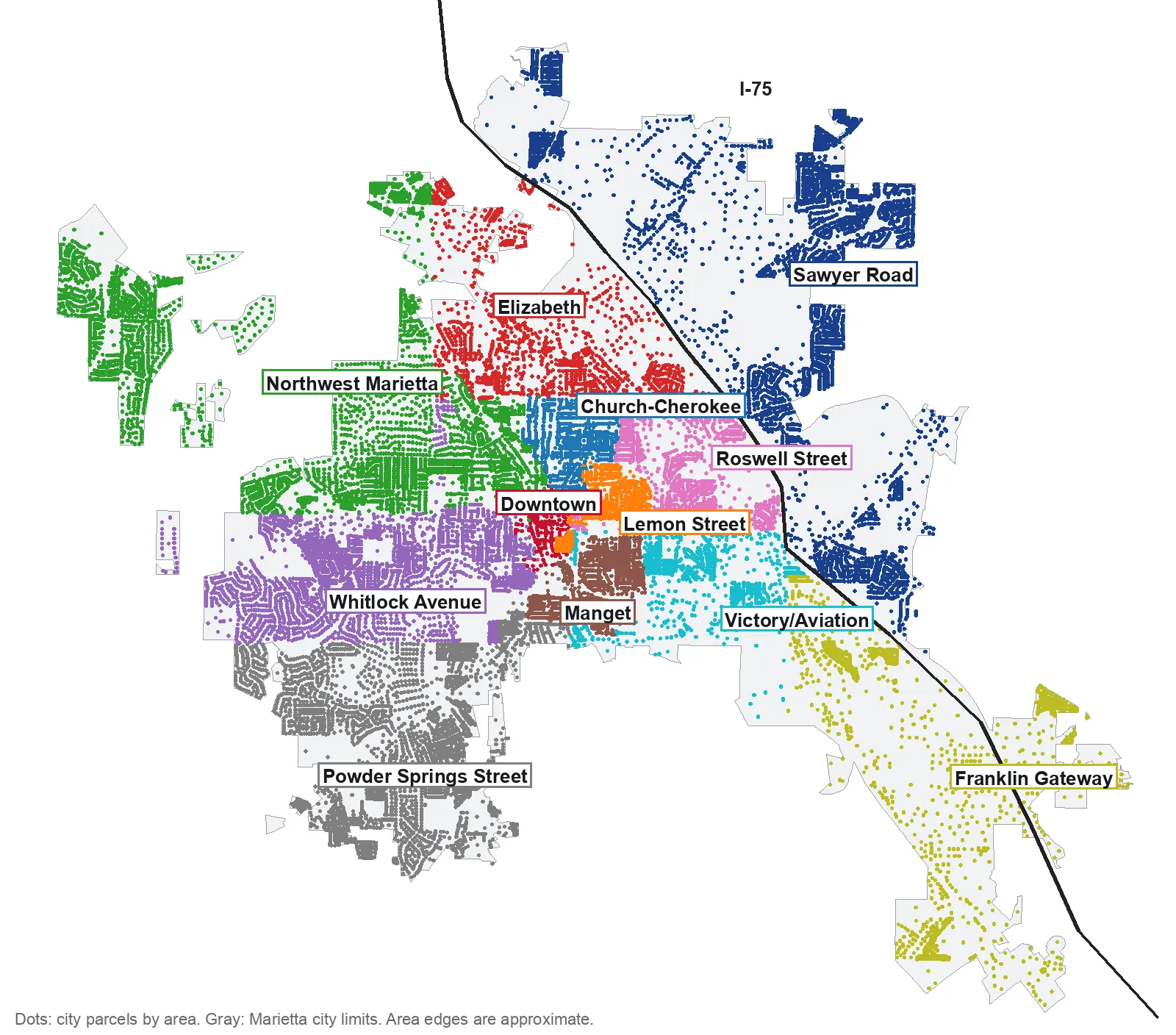
Map by Marietta Today. City limits and parcel locations are from the City of Marietta’s parcel map data; the line of I-75 is from OpenStreetMap, © OpenStreetMap contributors. Area edges are approximate.
Around the Square
Downtown. The Square and the city’s local Downtown Marietta Historic District. The city’s Envision plan calls it “an active, successful community center.”
Church-Cherokee. The Church Street-Cherokee Street and Forest Hills historic districts north of the Square, with the city’s Cherokee Heights neighborhood. Mostly West Side Elementary.
Lemon Street and Washington Avenue. East of the Square, with the Washington Avenue National Register district, which developed “from the 1830s through the 1930s,” and the Lemon Street School building.
Manget and Atlanta Street. South of the Square, the city’s Manget, Dixie/Atlanta and W. Dixie neighborhoods and the Atlanta-Frasier Street historic district. Mostly Park Street Elementary.
Roswell Street. Between Roswell Street and North Marietta Parkway, out to I-75 and the Big Chicken, with Custer Park and Marietta National Cemetery. Four elementary zones meet here.
West and north
Northwest Marietta and Kennesaw Avenue. The city’s first local historic district and the Northwest Marietta National Register district, out to Kennesaw Mountain. Mostly West Side Elementary.
Whitlock Avenue. The Whitlock Avenue historic district and the streets west to Marietta High, A.L. Burruss Elementary and Laurel Park.
Powder Springs Street. The southwest side, where the comprehensive plan envisions “a new neighborhood center at Powder Springs Street and Sandtown Road.” Split between Dunleith and Hickory Hills elementary schools.
Elizabeth. North of the parkway along Church Street Extension, Cherokee Street and Cobb Parkway, named for the place OpenStreetMap calls Elizabeth.
South and east
Victory/Aviation and Fairground Street. Home of the Bell Bomber houses built for the World War II bomber plant, the Cobb Civic Center, Kennesaw State’s Marietta campus and the Marietta Transfer Center.
Franklin Gateway. The redevelopment corridor along Franklin Gateway and Delk Road, with 15 apartment complexes and 4,002 units in the city’s data.
Sawyer Road. The city east of I-75, along Sawyer, Merritt, Roswell and Gresham roads, split between Sawyer Road and Lockheed elementary schools.
Comparing Marietta with its neighbors
Taxes, schools, home values and commutes for Marietta, Smyrna, Kennesaw and Mableton side by side: Marietta vs Smyrna vs Kennesaw vs Mableton. For the citywide market, see our home prices guide; for every school, registration and the choice program, our schools guide. Getting set up: moving to Marietta and property taxes.
How we built this
We named only areas a public source places on a map. The sources were:
- The city’s maps and plans. The four local historic districts on the city’s historic districts page and their map layer; the five National Register districts and their nomination forms; the 12 in-town neighborhoods in the city’s “Neighborhoods To Walk From” map layer; the districts in the 2019 Envision Marietta LCI update; and the Franklin Gateway and Powder Springs Gateway areas in the 2022 Comprehensive Plan.
- OpenStreetMap place names inside the city limits: Elizabeth, Oakton, Westoak and Whitlock.
- The city’s parcel data, which records each parcel’s ZIP code and zoned elementary school. Every city parcel was assigned to one area, and the school and ZIP shares on each page count those parcels, commercial parcels included.
Four plan areas have no boundary file, so we drew them along main roads: Roswell Street, Victory/Aviation, Franklin Gateway and Powder Springs Street. Sawyer Road and Elizabeth cover the parts of the city no plan names. The city takes registrations from homeowners and neighborhood associations but does not publish a list, so these pages do not list HOAs. We do not name individual subdivisions. The zone lookup and the county’s parcel records are the authority for any one address. Store and place data are © OpenStreetMap contributors.
Frequently asked questions
What are the neighborhoods in Marietta, Georgia?
Our guide covers 12 areas: Downtown, Church-Cherokee, Lemon Street and Washington Avenue, Manget and Atlanta Street, Roswell Street, Northwest Marietta and Kennesaw Avenue, Whitlock Avenue, Powder Springs Street, Elizabeth, Victory/Aviation and Fairground Street, Franklin Gateway and Sawyer Road. The names come from the city’s maps and plans and from OpenStreetMap.
What ZIP codes are in Marietta city limits?
City parcels fall mainly in 30064, 30060, 30062, 30008, 30067 and 30066, with a few in 30152 and 30068, according to the city’s parcel data. Many addresses in those ZIP codes are outside the city.
Do Marietta school zones follow the city limits?
Yes, for the district. Every address inside the city is in Marietta City Schools and zoned to Marietta High. A Marietta mailing address outside the city is usually in the Cobb County School District. Inside the city, seven elementary zones split the map.
Which side of I-75 is Marietta Square on?
The west side. Most of the city is west of I-75, but the city limits cross the interstate on the east side along Sawyer Road, Merritt Road and Roswell Road, and along Franklin Gateway and Delk Road in the southeast.
Have your say